Shasta Lake
Shasta Lake Kiteboarding Guide
Part of the State of Jefferson Kiteboarding Guide
Intro:
Shasta Lake is the largest reservoir in California with 365 miles of convoluted, mountainous and forested shoreline. Located just north of Redding in the Shasta-Trinity National Forest at an elevation of 1,067 feet, Shasta Lake offers challenging kiteboarding with superb scenery and sporty launches.

The southern ends of the McCloud River and Sacramento River Arms run north and south and offer your best options for catching wind.
Season:
The lake enjoys a long season due to low elevation at the north end of the sunny and warm Sacramento Valley. The number of rideable days is influenced largely by the occurance of passing fronts. North winds seem to be the best. Summer temperatures can get in the triple digits so calculate that into the equation when selecting a kite size.
Launch:
Bailey Cove (I-5 O'Brien Exit): When water levels are approximately 25 feet below full or lower adequate open shoreline can be found. A 1.5 mile hike will get you to the eastern side of the Bailey Cove hiking trail and a point that sticks out into the McCloud River Arm of the lake. This is a loop trail and it's about the same distance either way. The launch is rocky, sloping and very tricky. This is an advanced launch so only venture out if the wind is solid and you can make it back to shore. Boat support and booties are a good idea.
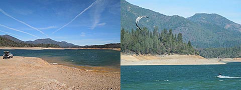
Jones Valley: North winds provide onshore conditions. At lower water levels you can drive right to the water's edge and find enough room to setup making this the easiest and relatively safest spot we have found to kite without a boat. This is a busy part of the lake with a public boat launch and marina so off season is recommended. If the wind doesn't cooperate checkout mountain biking or hiking on the Clikapudi Trail, an eight mile single track loop. 
Jones Valley - perfect late Feb. post frontal conditions!
Drift or Boat Launch: A boat is the ticket for kiting Shasta Lake otherwise you are limited to spots that are accessable from shore and public access points.
Hazards:
Boat traffic during the peak summer season is an obvious risk. A swim could result in a long walk due to the convoluted shoreline. Poison oak and rattle snakes are common. Power lines over the Pit River Arm near the I-5 Pit River bridge.
Wind & Water Data:
NWS - Shasta Lake Point Forecast
Shasta Lake Water Level (Daily Reservoir Elevation)
Camping:
Both public and private campgrounds abound around the lake.
